• Skip to primary navigation
  • Skip to main content
The GIS Blog by Nobel Systems

Powered by Nobel Systems

All about GIS, Cloud Solutions, Mapping, Business Intelligence, and Geospatial Analysis

  • GIS Technology
    • GeoViewer
    • GIS Billing
    • Public/Community View
    • Spatial Analysis
  • Utility Management
    • Water Utility Management
    • Wastewater Management
    • Utility Case Studies
  • IoT
  • AI
  • News
    • Featured
  • Contact
    • Subscribe
  • Show Search
Hide Search
You are here: Home / Archives for GIS Technology / Spatial Analysis

Spatial Analysis

GIS Maps Help Governments, Health Organizations Track COVID-19

Aretha Samuel ยท Leave a Comment

COVID-19 GIS maps

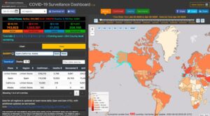
Various health, governmental, business, and other organizations have created Geographic Information Systems (GIS) maps to track the spread of COVID-19. Epidemiologists use GIS to look at variables, including demographics, environmental conditions, and historical data from past pandemics to determine the outbreak origins of COVID-19, the spread pattern of the disease, and the density of infection. […]

Nobel Systems, Inc. © 2023

  • About
  • Contact