

Cloud-based IoT and GIS utility compliance solutions enable real-time operations monitoring, inspections, and reporting. The U.S. Environmental Protection Agency (EPA) estimates more than 40,000 sanitary sewer overflows (SSO) occur every year. Sewer main blockages caused 48% of these overflows, and 47% of those blockages are FOG-related (fats, oil, and grease). It is critical for wastewater […]
Search Results for: geoviewer mobile
In Action: GIS Public View Application for City of Mission Viejo | Video
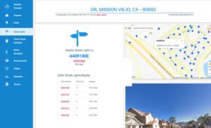
More cities are using Geographic Information Systems (GIS) to enable residents to access information and detailed data about where they live and work. The City of Mission Viejo offers its citizens the GIS GeoViewer Public application developed by Nobel Systems. The GIS GeoViewer Public View app provides detailed geographic information about properties, neighborhoods, and services within the city. […]
Learn How IoT Helps Water Utilities Manage Assets
Recent GIS Day events show how the world is embracing GIS (geographic information systems) and IoT (Internet of Things) in ever-increasing ways in business and everyday life. From GPS navigation on mobile devices, and mapping firestorms and lava flows, to asset management for utilities, the capabilities of advancing GIS/IoT technologies seems endless. Watch our video […]
Transforming to Success: Nobel Systems’ Senior Project Manager Papegowda B J

Papegowda B J is the senior project manager for GIS Cloud Solutions company Nobel Systems. His professional experience includes seven years in the field of IT, Web Development and GIS, and eight years of professional experience in GIS Data Conversion projects. When he started at Nobel Systems 16 years ago, however, he had no programming […]
The Facts Between GIS and GPS
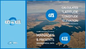
Data collection is easier today than it once was due to technological advancements, especially with the development of technologies like Geographic Positioning Systems (GPS) and Geographic Information Systems (GIS). Companies can now focus on how to best use the magnitude of information available to them, an aspect of business facilitated by using a GIS. Since […]