
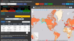
Various health, governmental, business, and other organizations have created Geographic Information Systems (GIS) maps to track the spread of COVID-19. Epidemiologists use GIS to look at variables, including demographics, environmental conditions, and historical data from past pandemics to determine the outbreak origins of COVID-19, the spread pattern of the disease, and the density of infection. […]
coronavirus
California Water Districts Take Measures to Protect Customers, Employees During Pandemic

While the world is battling the spread of COVID-19, private and public water and wastewater utilities in California are doing their part in making sure water supplies are safe during this critical time. Also, federal and global government officials assure the public that water supplies remain safe. The Environmental Protection Agency states on its Website […]