
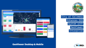
The City of Calimesa in Riverside County, Calif. has contracted to utilize Nobel Systems’ GeoViewer Enterprise to enhance its existing GIS mapping systems and manage city assets. The city will use GeoViewer Online and Mobile to manage city infrastructure and assets via the software’s user-friendly interface. GeoViewer’s secure cloud-based software provides Calimesa city staff access […]
GIS technology
Nobel Systems Provides Grants to Water Districts in Need

The GIS SaaS company partners with U.S. water districts to donate equipment to water regions in the Philippines. World Water Day brings attention to the importance of keeping our global water supplies clean and safe, and to make sure that citizens worldwide have access to potable water. This World Water Day on March 22, the […]
Nobel Provides GeoViewer Services to San Francisco
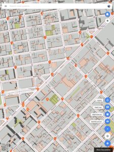
Nobel Systems has contracted to provide the City and County of San Francisco with its flagship GeoViewer Online and GeoViewer Mobile services. San Francisco city staff will use the GIS cloud mapping service to collect monument data in the field. San Francisco has 266 designated landmarks and monuments, many of which have been federally recognized. […]
The Facts Between GIS and GPS
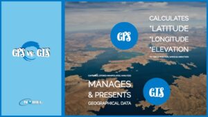
Data collection is easier today than it once was due to technological advancements, especially with the development of technologies like Geographic Positioning Systems (GPS) and Geographic Information Systems (GIS). Companies can now focus on how to best use the magnitude of information available to them, an aspect of business facilitated by using a GIS. Since […]
Why GIS in Urban Planning is Critically Important

The use of Geographic Information Systems or GIS in urban planning in North America and throughout the world has expanded at an exponential rate since the mid-1960s and early 1970s when Canada first used GIS to assess land inventory. A GIS is a software that captures, analyzes and manages spatial and geographical data. The Canadian […]