
Nobel Systems, a leader in operations management SaaS for the water/wastewater industry, and Multi-Energy Group (MEG), an expert engineering, and program management company, have engaged in a strategic partnership. MEG will provide sales and service support for Nobel Systems’ GeoViewer software. Nobel Systems provides real-time, map-based operations management solutions for the water and wastewater industries. […]
wastewater management
Fixing the Nation’s Aging Water Infrastructure with Data-Driven Technology
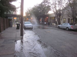
The failing state of the nations’ water infrastructure has been brought to light in recent headline news with costly water main ruptures and the resulting water loss and damages. The worrisome state of water distribution systems in the United States. has highlighted the urgency in adopting modern water management technologies. The use of modern technology […]
ACE19: Improving Water Management with Innovative Technology

Nobel Systems joins fellow water industry leaders in showcasing the latest technologies in smart water management. The 138th Annual Conference and Exposition (ACE19) of the American Water Works Association (AWWA) returns this year with the theme of “Innovating the Future of Water.” The conference takes place at the Colorado Convention center in Denver, June 10 […]
Nobel Systems Talks GIS Water Management at Philippine Water Expo
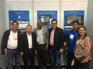
Nobel Systems team members along with the company’s President Michael Samuel attended the Philippine Water Expo in Manila last week. The expo, which took place at SMX Convention Center in Pasay City, Metro Manila, is designed to gather water and wastewater industry professionals, experts, and governmental representatives from throughout the world to share and explore […]
How to Create a Work Order in GeoViewer™ | GIS Software Video Tutorial
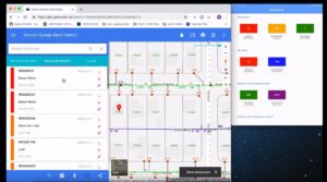
The following tutorial shows field staff and utility adminstators how to create a work order with the GIS software application GeoViewer™ from Nobel Systems. GeoViewer is used to monitor and manage water utility assets. Field staff can view, analyze and collect critical GIS data, online or offline. Adminstrators can track hours, equipment, materials, and contractors. […]