

International Women in Engineering Day (INWED) was founded by the Women’s Engineering Society in the U.K. on June 23, 2014, as a national event to celebrate the society’s 95th anniversary. It was soon adopted by the global community in 2017 and has become a day that celebrates women in engineering and encourages girls to pursue their […]
Nobel Provides GeoViewer Services to San Francisco
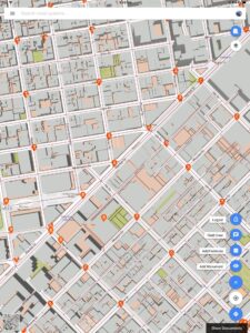
Nobel Systems has contracted to provide the City and County of San Francisco with its flagship GeoViewer Online and GeoViewer Mobile services. San Francisco city staff will use the GIS cloud mapping service to collect monument data in the field. San Francisco has 266 designated landmarks and monuments, many of which have been federally recognized. […]
Nobel Systems to be Featured at AWWA ACE18 Innovation Lounge June 12-14 in Las Vegas

Nobel Systems has been selected to exhibit at this year’s American Water Works Association (AWWA) Annual Conference & Exhibition Innovation Lounge in Las Vegas June 12 -14. The event takes place at the Mandalay Bay Conference Center. This is an invitation-only lounge that showcases companies with the latest, state-of-the-art technologies for the water management industry. […]
Nobel Systems Installs GeoViewer IoT Water Monitoring System for Mission Springs Water District
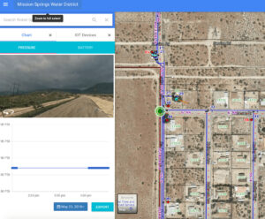
Nobel Systems has installed GeoViewer IoT, a real-time pressure monitoring system for the Mission Springs Water District in Desert Hot Springs, CA. The system monitors water pressure along the district’s utility lines using a GIS map-based system. If a leak or break occurs anywhere along the system, the water district employees are immediately notified via […]
The Facts Between GIS and GPS
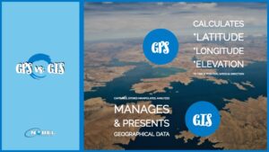
Data collection is easier today than it once was due to technological advancements, especially with the development of technologies like Geographic Positioning Systems (GPS) and Geographic Information Systems (GIS). Companies can now focus on how to best use the magnitude of information available to them, an aspect of business facilitated by using a GIS. Since […]