
Nobel Systems is hosting a one-day live event in line with Nobel’s vision to modernize how organizations maintain and manage vital assets.
GIS and IoT
Nobel Systems to Supply Digital Twin Analysis System to Uzbekistan National Water Provider
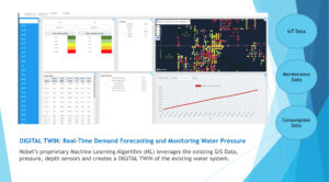
The Digital Twin system utilizes geospatial technology such as GIS and other fundamental data sources and IoT network sensor devices to help Uzsuvtaminot manage and monitor network performance in real-time.
Innovative Technologies for Water Asset Management: Increasing Efficiency and Creating a Better Future

The benefits of IoT and geospatial technology are getting well-deserved attention. This article highlights how innovative technologies are changing the traditional water utility industry. The Future of Water Utilities Every new technology brings changes to the core principles of the water industry. As a result, innovation in the water sector is an ongoing process that […]
How Digital Twin Technology Helps Utilities Avoid Critical Mistakes
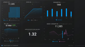
Today, with advancements in technology, it is vital for utilities to manage operations in real-time. In addition, it is critical to monitor assets and operations to prevent problems before they happen, allay downtimes, and explore new opportunities or plan for the future. Digital Twin Technologies enable utilities to do all this and more. To help […]
ACE19: Improving Water Management with Innovative Technology
Nobel Systems joins fellow water industry leaders in showcasing the latest technologies in smart water management. The 138th Annual Conference and Exposition (ACE19) of the American Water Works Association (AWWA) returns this year with the theme of “Innovating the Future of Water.” The conference takes place at the Colorado Convention center in Denver, June 10 […]